


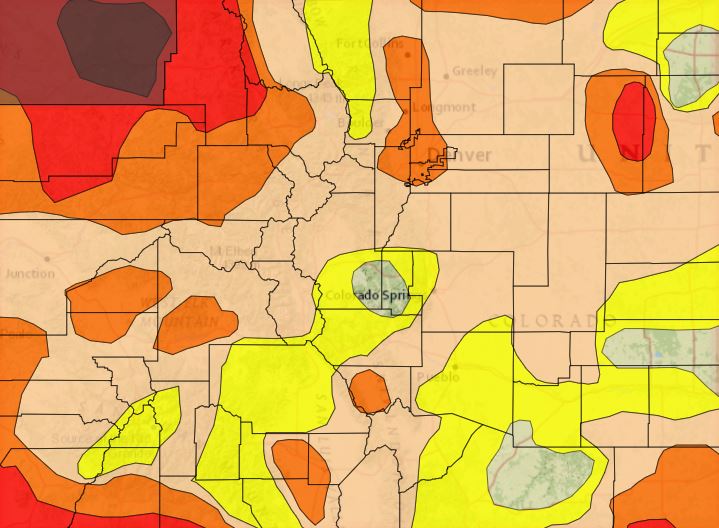
According to the October 26 update from the National Integrated Drought Information System (NIDIS), 2% of Colorado falls into the exceptional drought category, 11% is in an extreme drought, 30% is in a severe drought, 75% is in a moderate drought, and 96% of the state is abnormally dry. The map featured above shows the drought conditions on October 26.
The 2021 Water Year ended on September 30. According to the latest meeting of the Colorado Water Board’s Water Availability Task Force, Colorado experienced the 4th warmest summer on record in 127 years on record. It is expected that La Nina conditions will continue through the fall months and persist through winter and early spring, followed by ENSO-neutral conditions in late spring and early summer of 2022.
As of November 1, cumulative precipitation in the Colorado River watershed was tracking at 102% of average and the South Platte River watershed was tracking at 31% of average.
As of November 1, snowpack in the South Platte River Watershed was at 43% of normal with a percent of normal peak at 3% while snowpack in the Colorado River Watershed was at 93% of normal with a peak of 5% of normal.
Denver Water’s reservoir levels are 85% full which is the same as it was this time last year. Denver Water’s supply reservoir contents as of November 1 are represented in the table below.
| Reservoir | Percent Full: Current | Percent Full: Historical Median |
|---|---|---|
| Antero | 101% | 99% |
| Eleven Mile | 102% | 102% |
| Cheesman | 82% | 83% |
| Marston | 67% | 54% |
| Strontia Springs | 87% | 94% |
| Chatfield | 96% | 95% |
| Dillon | 84% | 88% |
| Gross | 21% | 38% |
| Ralston | 62% | 52% |
| Meadow Creek | 0% | 12% |